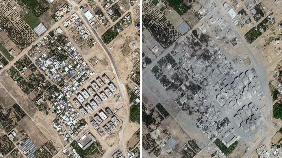
From above, a silent narrative unfolds—a landscape transformed by conflict, captured in stark pixels and cold digital resolution. Satellite imagery offers an unflinching chronicle of destruction, revealing the Gaza Strip’s dramatic metamorphosis from a populated terrain to a scarred, fragmented geography. These aerial perspectives strip away the human drama to present a clinical, geometric testament to the brutal consequences of war, where neighborhoods dissolve into rubble, infrastructure crumbles, and entire urban ecosystems are systematically dismantled. Each before-and-after frame tells a story of irreversible change, mapping the invisible wounds of a conflict that reshapes not just buildings, but the very contours of human existence. Stark satellite imagery reveals the profound transformation of the Gaza Strip’s landscape, documenting the extensive destruction wrought by months of intense conflict. Urban areas once bustling with life now appear as fragmented, dust-colored expanses marked by crumbling infrastructure and widespread demolition.
Aerial perspectives capture entire neighborhoods reduced to rubble, with geometric patterns of devastation replacing complex cityscapes. Buildings that once stood as testament to community and resilience now exist as skeletal remnants, their structural integrity completely compromised by sustained military operations.
Comparison photographs document the dramatic shift from densely populated regions to moonscape-like terrains, where residential blocks and infrastructure have been systematically dismantled. Neighborhoods that previously showcased intricate urban planning now resemble apocalyptic scenes of total obliteration.
Satellite technology provides an unfiltered, clinical view of the conflict’s human impact, transforming abstract geopolitical tensions into tangible visual evidence. Each pixel represents not just physical destruction, but the profound humanitarian consequences of prolonged warfare.
Infrastructure networks—roads, utilities, and communication systems—appear as fractured, interrupted lines, symbolizing the systematic breakdown of essential community supports. Vast swathes of formerly thriving districts now present as monochromatic expanses of debris and collapsed structures.
Technological advancements in satellite imaging allow unprecedented documentation of conflict’s spatial dimensions. High-resolution photographs capture nuanced details, revealing the granular extent of architectural and environmental transformation.
Agricultural zones surrounding urban centers show similar patterns of comprehensive destruction. Farmlands, once productive and verdant, now appear as scarred, discolored terrain, reflecting the conflict’s broader ecological consequences.
The visual narrative extends beyond mere architectural damage, presenting a comprehensive documentation of societal disruption. Each image serves as a forensic record, silently testifying to the complex geopolitical dynamics that precipitate such extensive devastation.
Comparative satellite imagery provides an objective, unemotional chronicle of the conflict’s geographical impact. The photographs transcend traditional reporting, offering a detached yet profoundly telling perspective on the human cost of sustained military engagement.
These visual documents serve not just as historical records but as potential evidence for future investigations, diplomatic discussions, and humanitarian assessments. They transform abstract geopolitical conflicts into tangible, irrefutable visual statements about the real-world consequences of prolonged territorial disputes.
The satellite photographs ultimately present a haunting testament to the transformative power of conflict, revealing how human interventions can fundamentally alter geographical landscapes in remarkably short periods.